Manaslu (Nepali: मनास्लु), also known as Kutang) is the eighth highest mountain in the world, and is located in the Mansiri Himal, part of the Nepalese Himalayas, in the west-central part of Nepal. Its name, which means "Mountain of the Spirit", comes from the Sanskrit word Manasa, meaning "intellect" or "soul". Manaslu was first climbed on May 9, 1956 by Toshio Imanishi and Gyalzen Norbu, members of a Japanese expedition. It is said that "just as the British consider Everest their mountain, Manaslu has always been a Japanese mountain".
Manaslu at 8,156 metres (26,759 ft) above mean sea level (m.s.l) is the highest peak in the Lamjung District and is located about forty miles east of Annapurna. The mountain's long ridges and valley glaciers offer feasible approaches from all directions, and culminate in a peak that towers steeply above its surrounding landscape, and is a dominant feature when viewed from afar.
The Manaslu region offers a variety of trekking options. The popular Manaslu trekking route of 177 kilometres (110 mi), skirts the Manaslu massif over the pass down to Annapurna. The Nepalese Government only permitted trekking of this circuit in 1991. The trekking trail follows an ancient salt-trading route along the Budhi Gandaki river. En route, 10 peaks over 6,500 metres (21,300 ft) are visible, including a few over 7,000 metres (23,000 ft). The highest point reached along the trek route is the Larkya La at an elevation of 5,235 metres (17,175 ft). As of May 2008, the mountain has been climbed 297 times with 53 fatalities.
Manaslu Conservation Area has been established with the primary objective of achieving conservation and sustainable management of the delimited area, which includes Manaslu.
Set in the northern Himalayan range in the Gorkha land of Nepal, Manaslu is a serrated "wall of snow and ice hanging in the sky".[citation needed] The three sides of the mountain fall in steps to terraces down below, which are sparsely inhabited with agricultural operations practiced on the land. Apart from climbing Manaslu, trekking is popular in this mountain region, as part of the Manaslu Circuit, a notable path by trekkers in Nepal.
The Manaslu Conservation Area, declared as such in December 1998 under the National Parks and Wild Life Conservation Act, subsumes Manaslu within it. The area covered under the conservation zone is 1,663 square kilometres (642 sq mi) and is managed by the National Trust for Nature Conservation (NTNC) of Nepal. The status of "conservation area" applied to the Manaslu area or region was with the basic objective "To conserve and sustainable management of the natural resources and rich cultural heritage and to promote ecotourism to improve livelihood of the local people in the MCA region.
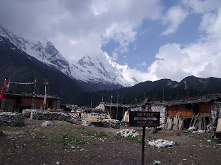
Manaslu Himal, as it is popularly known among trekkers, provides views of the snow-covered mountains of the Himalayas and allows close interaction with the different ethnic groups who live in hill villages scattered along the trek route.
The trekking route is through mountains prone to the consequences of monsoon rainfall, land slides and land falls. Encounters with passing yaks, and hypothermia and altitude sickness, are common. Trekking to Manaslu is thus a test of endurance. The region, which is also termed the Manaslu Conservation Area, comprises sub-tropical Himalayan foothills to arid Trans-Himalayan high pastures bordering Tibet. Starting from Arughat and extending into the Larkhe La pass, the area covers six climatic zones: the tropical and sub-tropical zone, elevation varies from 1,000–2,000 meters (3,300–6,600 ft); the temperate zone (within elevation range of 2,000–3,000 metres (6,600–9,800 ft); the sub-alpine zone elevation range of 3,000–4,000 metres (9,800–13,000 ft); the alpine zone, a range of 4,000–5,000 meters (13,000–16,000 ft)) meadows; and the arctic zone (lying above 4,500 metres (14,800 ft)). The zones coalesce with the variation of the altitude from about 600 metres (2,000 ft) in the tropical zone to the 8,156 metres (26,759 ft) summit of Manaslu in the arctic zone.
Manaslu is known in the Tibetan language as "Kutan l", in which "tang" means the Tibetan word for a flat place. It is a very large peak with an elevation of 8,156 metres (26,759 ft) (the world’s eighth highest mountain). In view of its favorable topography of long ridges and glacial valleys, Manaslu offers several routes to mountaineers. Important peaks surrounding Manaslu include Ngadi Chuli, Himalchuli and Baudha. A glacial saddle known as Larkya La, with an elevation of 5,213 metres (17,103 ft), lies across the Nepal–Tibet border. The peak is bounded on the east by the Ganesh Himal and the Buri Gandaki River gorge, on the west by the deep fissures of the Marysyangdi Khola with its Annapurna range of hills, to the south is the Gorkha town at the foot of the hill (from where trekking operates during the season), which is an aerial distance of 48 kilometres (30 mi) to the peak. There are six established trek routes to the peak, and on the mountain the south face is reportedly the most difficult for climbing.
 The permanent snow line is reckoned above 5,000 metres (16,000 ft)
elevation. Precipitation in the area is both from snowfall and rainfall;
the average annual rainfall is about 1,900 millimetres (75 in) mostly
during the monsoon period, which extends from June to September. The
temperatures in the area also vary widely with the climatic zone: in the
subtropical zone, the average summer and winter temperatures vary in
the range of 31–34 °C (88–93 °F) and 8–13 °C (46–55 °F) respectively; in
the temperate climatic zone, the summer temperatures are 22–25 °C
(72–77 °F) and winter temperatures are -2–6 °C (28–43 °F) when snow and
frost are also experienced; in the sub-alpine
The permanent snow line is reckoned above 5,000 metres (16,000 ft)
elevation. Precipitation in the area is both from snowfall and rainfall;
the average annual rainfall is about 1,900 millimetres (75 in) mostly
during the monsoon period, which extends from June to September. The
temperatures in the area also vary widely with the climatic zone: in the
subtropical zone, the average summer and winter temperatures vary in
the range of 31–34 °C (88–93 °F) and 8–13 °C (46–55 °F) respectively; in
the temperate climatic zone, the summer temperatures are 22–25 °C
(72–77 °F) and winter temperatures are -2–6 °C (28–43 °F) when snow and
frost are also experienced; in the sub-alpine
zone, during December to May snowfall generally occurs and the mean annual temperature is 6–10 °C (43–50 °F). The arctic zone is distinct and falls within the permanent snow line; there, the temperatures lie much below freezing zone http://www.nepalguideinfo.com/Manaslu-Trek.php http://www.nepalguideinfo.com/Manaslu-Trek.php http://www.nepalguideinfo.com
http://www.nepalguideinfo.com
http://www.hikehimalayas.com
Email-sanjib-adhikari@hotmail.com
P.O.BOX=4453
Kathmandu Nepal


Manaslu at 8,156 metres (26,759 ft) above mean sea level (m.s.l) is the highest peak in the Lamjung District and is located about forty miles east of Annapurna. The mountain's long ridges and valley glaciers offer feasible approaches from all directions, and culminate in a peak that towers steeply above its surrounding landscape, and is a dominant feature when viewed from afar.
The Manaslu region offers a variety of trekking options. The popular Manaslu trekking route of 177 kilometres (110 mi), skirts the Manaslu massif over the pass down to Annapurna. The Nepalese Government only permitted trekking of this circuit in 1991. The trekking trail follows an ancient salt-trading route along the Budhi Gandaki river. En route, 10 peaks over 6,500 metres (21,300 ft) are visible, including a few over 7,000 metres (23,000 ft). The highest point reached along the trek route is the Larkya La at an elevation of 5,235 metres (17,175 ft). As of May 2008, the mountain has been climbed 297 times with 53 fatalities.
Manaslu Conservation Area has been established with the primary objective of achieving conservation and sustainable management of the delimited area, which includes Manaslu.
Set in the northern Himalayan range in the Gorkha land of Nepal, Manaslu is a serrated "wall of snow and ice hanging in the sky".[citation needed] The three sides of the mountain fall in steps to terraces down below, which are sparsely inhabited with agricultural operations practiced on the land. Apart from climbing Manaslu, trekking is popular in this mountain region, as part of the Manaslu Circuit, a notable path by trekkers in Nepal.
The Manaslu Conservation Area, declared as such in December 1998 under the National Parks and Wild Life Conservation Act, subsumes Manaslu within it. The area covered under the conservation zone is 1,663 square kilometres (642 sq mi) and is managed by the National Trust for Nature Conservation (NTNC) of Nepal. The status of "conservation area" applied to the Manaslu area or region was with the basic objective "To conserve and sustainable management of the natural resources and rich cultural heritage and to promote ecotourism to improve livelihood of the local people in the MCA region.
Manaslu Himal, as it is popularly known among trekkers, provides views of the snow-covered mountains of the Himalayas and allows close interaction with the different ethnic groups who live in hill villages scattered along the trek route.
The trekking route is through mountains prone to the consequences of monsoon rainfall, land slides and land falls. Encounters with passing yaks, and hypothermia and altitude sickness, are common. Trekking to Manaslu is thus a test of endurance. The region, which is also termed the Manaslu Conservation Area, comprises sub-tropical Himalayan foothills to arid Trans-Himalayan high pastures bordering Tibet. Starting from Arughat and extending into the Larkhe La pass, the area covers six climatic zones: the tropical and sub-tropical zone, elevation varies from 1,000–2,000 meters (3,300–6,600 ft); the temperate zone (within elevation range of 2,000–3,000 metres (6,600–9,800 ft); the sub-alpine zone elevation range of 3,000–4,000 metres (9,800–13,000 ft); the alpine zone, a range of 4,000–5,000 meters (13,000–16,000 ft)) meadows; and the arctic zone (lying above 4,500 metres (14,800 ft)). The zones coalesce with the variation of the altitude from about 600 metres (2,000 ft) in the tropical zone to the 8,156 metres (26,759 ft) summit of Manaslu in the arctic zone.
Manaslu is known in the Tibetan language as "Kutan l", in which "tang" means the Tibetan word for a flat place. It is a very large peak with an elevation of 8,156 metres (26,759 ft) (the world’s eighth highest mountain). In view of its favorable topography of long ridges and glacial valleys, Manaslu offers several routes to mountaineers. Important peaks surrounding Manaslu include Ngadi Chuli, Himalchuli and Baudha. A glacial saddle known as Larkya La, with an elevation of 5,213 metres (17,103 ft), lies across the Nepal–Tibet border. The peak is bounded on the east by the Ganesh Himal and the Buri Gandaki River gorge, on the west by the deep fissures of the Marysyangdi Khola with its Annapurna range of hills, to the south is the Gorkha town at the foot of the hill (from where trekking operates during the season), which is an aerial distance of 48 kilometres (30 mi) to the peak. There are six established trek routes to the peak, and on the mountain the south face is reportedly the most difficult for climbing.
- Climate

zone, during December to May snowfall generally occurs and the mean annual temperature is 6–10 °C (43–50 °F). The arctic zone is distinct and falls within the permanent snow line; there, the temperatures lie much below freezing zone http://www.nepalguideinfo.com/Manaslu-Trek.php http://www.nepalguideinfo.com/Manaslu-Trek.php http://www.nepalguideinfo.com
http://www.nepalguideinfo.com
http://www.hikehimalayas.com
Email-sanjib-adhikari@hotmail.com
P.O.BOX=4453
Kathmandu Nepal


